I'm gonna attempt to tackle this Norumbega, a.k.a city of Bega, Nurumberg, Nurumbega, Nurembega, Norobega, Oranbega legend. There are quite a few fascinating occurrences related to this so-called "legendary settlement" located in the northeastern part of North America. Reading the official narrative of Norumbega, it appears that they do not outright dismiss its existence, but rather reduce its "correct" description to nothing but a small settlement. Obviously, the houses with pillars of gold, and inhabitants who carried quarts of pearls on their heads are being officially presented as an example of a 500 year old vivid imagination. To be fair, we do have very very old texts questioning the existence of this Norumbega City.
Suspicious fact: Ingram’s narrative of his alleged travels, A true discourse of the adventures and travailes of David Ingram, was published in 1583, but no copy is known to survive (see W. A. Jackson, “Humphrey Dyson’s library,” Amer. Biblio. Soc. Papers, XLIX (1949), 285, and Roanoke voyages (Quinn), I, 3–4). It was reprinted by Richard Hakluyt in Principall navigations (1589), 557-62, only (and in Voyages of Gilbert (Quinn), II, 283-96).
The Long, Forgotten Walk of David Ingram
Biography – Ingram, David – Volume I (1000-1700)
Given that the original text published in 1583 has no surviving copies, the best version of Ingram’s account we have is called Land Travels of Davyd Ingram. I have my doubts as to why "no copy is known to survive". May be today's scholars should check for one at the Vatican Library Secret Archives. At least they know what the name of the text is.
Norumbega language sounding like "Latin" added a peculiar twist to this entire story-legend. This fact, or speculation is obviously not verifiable from whatever angle you approach the issue.
Puzzle from David Ingram: 16th century Penguins - here is some penguin etymology for consideration.
Official: the word "Norumbega" was originally spelled Oranbega in Giovanni da Verrazzano's 1529 map of America, and the word is believed to derive from one of the Algonquian languages spoken in New England. It may mean "quiet place between the rapids" or "quiet stretch of water".
Now, I'm not an expert in the origin of words, but something in the official narrative was smelling of "we do not really know, but here is a version for you". I googled some, and found this 1884 book "The Discoveries of America to the Year 1525, Volume 1" by Arthur James Weise. I read Mr' Weise's explanation, and was surprised to see all the speculations he indulged in, to get his point across: pages 348, 349, and 350.
With one of the original spellings being "Nurumbega", it appeared that we had a two part word with "nurum", and "bega" being the parts. I turned to Google Translate.
Additionally, Norumbega was also being referred to as "city of Bega". One way or the other, the only more or less constant part of the word appears to be this "bega".
With 16th century maps being predominantly in Latin, "nurum" very quickly produced "a daughter". The "bega" part proved to be more challenging, for it was not really producing anything. For sure, this "bega" could have been some sort of a derivative from "berg". I did find "berga" on one of the maps, and naturally my "bega" investigation could be based on the misleading info. Anyways, I figured that "bega" could be a name, kind of like "Nurum Bega". You can imagine my surprise when I found a candidate for this "bega" person, who ended up being an Irish Princess.

"The most likely time for this (KD: Saint Bega's existence) would have been after AD 850, when the Vikings were settling Ireland." - Wiki

Celts to the Creche: St. Bega of Bees
Commemorated: Saint Bega, Anchoress of Cumbria
St. Bega - Saints & Angels
Saint Bega - Wikipedia
Saint Bega - Newman Connection - Effingham, IL

KD: Anyways, I do not know if my name interpretation has any scientific merit, but this version is mine, and for the time being I'm sticking to it. It does appear that wherever this legendary Irish princess ended up after fleeing Cumbria is not set in stone. With all the "Viking-American" connections present in history, why not America? Would a princess run on her own, or accompanied by some loyal knights? I do not know, and I do not think the official version knows either.
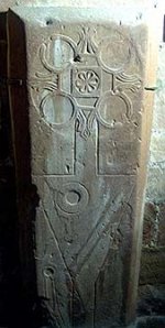
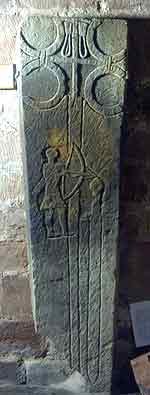
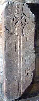
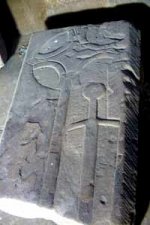
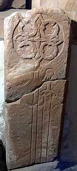
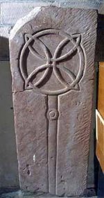
Of additional interest could be certain historic artifacts associated with Saint Bega, who, at least for a period of several years, was associated with the village of Saint Bee in Cumbria. Here are some of those artifacts.
Source for the above mages: Old European culture: St Bega
So, what do we have for Norumbega on the maps? Quite some I have to say, but first let's see where our current scientist place Norumbega area on the today's map. Don't get me wrong, they do not entertain an idea of the City of Bega having been located there. It is, more or less, the area where this "never found" city was predominantly looked at for. Yup, they deliberately looked for it in the area where it was never located to start with.
Vicinity of the Penobscot Bay in Main, this is where the search for Norumbega was supposedly conducted at. I put a little red star next to the general area of the search.
The end result we know - the City of Bega was never found. Meanwhile a whole bunch of places in the State of Maine, as well as Massachusetts, started to display the word "Norumbega" as a part of their name.

Apparently Boston could be a possible candidate for the Norumbega City location. At least Andy Woodruff presents an interesting case in his article
Chesipooc Sinus (lat. for Bay or Gulf) = Chesapeake Bay. Roanoke Island (NC) is marked with a tooltip on the left portion of the below map. The Chesapeake Bay entrance on the left portion of the map was added by me.

The below compilation does not match as nicely as the above one. Things are not as much to scale. Whatever the reasons are, remains to be determined. There were a lot of strange outline changes in our recent past, well, at least it appears that way. One way or the other, this Norumbega appears to be very far from the State of Maine and its Penobscot Bay. Yet, this is where the search was supposedly conducted.

Part of Abraham Ortelius' atlas from 1570, showing "Norvmbega" among other somewhat mythical names. Any guesses why the names are considered to by "mythical"?

In reality, there are quite a few maps displaying Norumbega.
KD: This is Part I. Parts I & II are below.
- First appearance on a map: originally spelled Oranbega in Giovanni da Verrazzano's 1529 map of America
- Oranbega was allegedly discovered by Verrazano's brother during his 1524 voyage
- First land of Norumbega description: In 1542-43 Jean Alfonse described a land he called Norombega.
- The river is more than 40 leagues wide at its entrance and retains its width some thirty or forty leagues. It is full of Islands, which stretch some ten or twelve leagues into the sea. ... Fifteen leagues within this river there is a town called Norombega, with clever inhabitants, who trade in furs of all sorts; the town folk are dressed in furs, wearing sable. ... The people use many words which sound like Latin. They worship the sun. They are tall and handsome in form. The land of Norombega lies high and is well situated.
- First (and last?) visit of he city of Norumbega: In 1568-69 by David Ingram
- Norumbega, or Nurembega, is a legendary settlement in northeastern North America which appeared on many early maps from the 1500s until American colonization. The houses were said to have pillars of gold and the inhabitants carried quarts of pearls on their heads.
- Jean Allefonsce in 1542 reported that he had coasted south from Newfoundland and had discovered a great river. It often appeared on subsequent European maps of North America, lying south of Acadia in what is now New England. The town of Bangor, Maine, embraced the legend in the nineteenth century, naming their municipal hall "Norumbega Hall". In 1886 inventor Joseph Barker Stearns built a mansion named "Norumbega Castle", which still stands on US Route 1 in Camden, Maine, overlooking Penobscot Bay.
- In the late 19th century, Eben Norton Horsford linked the name and legend of Norumbega to supposed Norse settlements on the Charles River, and built the Norumbega Tower at the confluence of Stony Brook and the Charles in Weston, Massachusetts, where he believed Fort Norumbega was located. In honor of Horsford's generous donations to Wellesley College, a building named Norumbega Hall was dedicated in 1886 and celebrated in a poem by John Greenleaf Whittier.
- The word "Norumbega" was originally spelled Oranbega in Giovanni da Verrazzano's 1529 map of America, and the word is believed to derive from one of the Algonquian languages spoken in New England. It may mean "quiet place between the rapids" or "quiet stretch of water".
- Today, the myth is reflected in such place names as Norumbega Mountain (formerly Brown Mountain) in Acadia National Park.
The Legend of Norumbega
Apparently, the "legend" of Norumbega, was in part attributed to a certain illiterate British sailor named David Ingram. He made his way from Texas to Maine, and beyond to the St. John's river, where he was picked up by a friendly French ship and carried to France, and so got home to England. The journey across North America took him about eleven months, but one of his comrades, Job Hortop, had no end of adventures, and was more than twenty years in getting back to England. Ingram told such blessed yarns about houses of crystal and silver, and other wonderful things, that many disbelieved his whole story, but he was subjected to a searching examination before Sir Francis Walsingham, and as to the main fact of his journey through the wilderness there seems to be no doubt.Suspicious fact: Ingram’s narrative of his alleged travels, A true discourse of the adventures and travailes of David Ingram, was published in 1583, but no copy is known to survive (see W. A. Jackson, “Humphrey Dyson’s library,” Amer. Biblio. Soc. Papers, XLIX (1949), 285, and Roanoke voyages (Quinn), I, 3–4). It was reprinted by Richard Hakluyt in Principall navigations (1589), 557-62, only (and in Voyages of Gilbert (Quinn), II, 283-96).
- David Ingram (dates uncertain) was a 16th-century English sailor and explorer who claimed to have walked across the interior of the North American continent from Mexico to Nova Scotia in 1568. Ingram signed on with English privateer John Hawkins in 1567 to raid and trade along the coasts of Portuguese Africa and Spanish Mexico. In November 1567, he was marooned with some 100 of his shipmates near Tampico on the coast of Mexico, about 200 miles south of the present Texas/Mexico border. Ingram and two dozen of his party struck out northward into the interior to avoid capture by the Spanish, and disappeared off the map. 11 months later, in October 1568, Ingram and two others of his original party were picked up from the coast of Nova Scotia by a French fishing vessel. How they got there is attested only by Ingram's own account, written down 13 years later in 1582 by Sir Francis Walsingham (Ingram himself was illiterate) and published in 1589 in Richard Hakluyt's "The Principall Navigations Voiges and Discoveries of the English Nation of 1589." Hakluyt's second edition in 1599 did not contain Ingram's account, possibly suggesting Hakluyt's doubts about it. Samuel Purchas commented on this writing that “It seemeth some incredibilities of his reports caused him to leave him out in the next impression, the reward of lying [being] not to be believed in truths.” Ingram returned to the new world in 1583 with Sir Humphrey Gilbert in his unsuccessful attempt to establish an English settlement in Newfoundland.
- He reported a populous and prosperous land dotted with large settlements, divided into a multitude of what he calls kingdoms with kings "carried by men in a sumptuous chaire of Siluer or Christal, garnished with divers sortes of precious stones.", mostly friendly and eager to help him along his journey. At the same time, much of his description of the country and its inhabitants seems fanciful, at least partly cobbled together from things he had seen or heard in his travels up and down the coasts of Africa and South America (he reported encountering elephants, a beast with "eyes and mouth … in his breast," and great cities "five or eight miles one from the other", e.g. "Bariniah, a Citie a mile and a quarter long" and that the Indians called certain birds "penguins" which he thought was just one of many Welsh words they used). Nevertheless, it is peppered with intriguing tidbits, including what may be the first recorded description of an American bison. Some scholars have questioned the entire story on the grounds that it would have been physically impossible to walk over 3,000 miles through the wilderness in only 11 months, but in 1999 British writer Richard Nathan retraced Ingram's journey in reverse, walking from Nova Scotia to Tampico in just 9 months.
The CastawaysYou will find it difficult to find these names in the history books and they are not easy to find on the internet. They are not among the lists of the great explorers, although David Ingram has an entry in the Dictionary of Canadian Biography under the heading ‘Explorer’ (David Quinn, 1966). Nonetheless these three illiterate English sailors made one of the most amazing journeys of all the amazing journeys in the Age of Discovery.
The Long, Forgotten Walk of David Ingram
Biography – Ingram, David – Volume I (1000-1700)
Given that the original text published in 1583 has no surviving copies, the best version of Ingram’s account we have is called Land Travels of Davyd Ingram. I have my doubts as to why "no copy is known to survive". May be today's scholars should check for one at the Vatican Library Secret Archives. At least they know what the name of the text is.
Ingram was interviewed (interrogated?) by Peckham and Walsingham in 1582: Richard Hakluyt’s Principal Navigations, Voyages, Traffiques and Discoveries of the English Nation.He saw kings decorated with rubies six inches long; and they were borne on chairs of silver and crystal, adorned with precious stones. He saw pearls as common as pebbles, and the natives were laden down by their ornaments of gold and silver. The city of Bega was three-quarters of a mile long and had many streets wider than those of London. Some houses had massive pillars of crystal and silver.
Norumbega language sounding like "Latin" added a peculiar twist to this entire story-legend. This fact, or speculation is obviously not verifiable from whatever angle you approach the issue.
Puzzle from David Ingram: 16th century Penguins - here is some penguin etymology for consideration.
Official: the word "Norumbega" was originally spelled Oranbega in Giovanni da Verrazzano's 1529 map of America, and the word is believed to derive from one of the Algonquian languages spoken in New England. It may mean "quiet place between the rapids" or "quiet stretch of water".
Now, I'm not an expert in the origin of words, but something in the official narrative was smelling of "we do not really know, but here is a version for you". I googled some, and found this 1884 book "The Discoveries of America to the Year 1525, Volume 1" by Arthur James Weise. I read Mr' Weise's explanation, and was surprised to see all the speculations he indulged in, to get his point across: pages 348, 349, and 350.
With one of the original spellings being "Nurumbega", it appeared that we had a two part word with "nurum", and "bega" being the parts. I turned to Google Translate.
Additionally, Norumbega was also being referred to as "city of Bega". One way or the other, the only more or less constant part of the word appears to be this "bega".
With 16th century maps being predominantly in Latin, "nurum" very quickly produced "a daughter". The "bega" part proved to be more challenging, for it was not really producing anything. For sure, this "bega" could have been some sort of a derivative from "berg". I did find "berga" on one of the maps, and naturally my "bega" investigation could be based on the misleading info. Anyways, I figured that "bega" could be a name, kind of like "Nurum Bega". You can imagine my surprise when I found a candidate for this "bega" person, who ended up being an Irish Princess.
Saint Bega
- St. Bega (other forms of her name are Begh and Bee) is said to have been Irish, though it is not clear whether she lived in the eighth or ninth century. In any case she was a virgin who led a holy life in north-western England. The legend says that she was an Irish princess, the most beautiful in her kingdom, who fled from her native land to avoid marriage with a pagan Viking—a Norwegian prince. Guided by an angel, Bega refused a pagan husband, as she wanted to devote her life to the Heavenly Bridegroom - Christ. Having crossed the Irish Sea and survived shipwreck, she was thrown ashore in the area to the south of the present-day Cumbrian town of Whitehaven in Copeland (in the north-west of England). Seeing in this a sign from God, Bega settled there in solitude and for many years lived as an anchoress.
- With time she may have founded a convent, though the nuns may have appeared after her repose, since the anonymous author of her life indicates that the holy virgin lived alone at Copeland. This convent was later called St. Bees after the saint.
Celts to the Creche: St. Bega of Bees
Commemorated: Saint Bega, Anchoress of Cumbria
St. Bega - Saints & Angels
Saint Bega - Wikipedia
Saint Bega - Newman Connection - Effingham, IL
- Bega crosses the sea in this boat and lands at St. Bees in western England where she lived for several years in the thick forests of Cumbria as a hermitess. She performs at least nine miracles while living there.
- Overtime, she begins to fear pirates who are landing in the area, so she quickly flees the area leaving her sacred arm-band behind on purpose so that miracles can continue in this place that sheltered her.
- Where did she go?
KD: Anyways, I do not know if my name interpretation has any scientific merit, but this version is mine, and for the time being I'm sticking to it. It does appear that wherever this legendary Irish princess ended up after fleeing Cumbria is not set in stone. With all the "Viking-American" connections present in history, why not America? Would a princess run on her own, or accompanied by some loyal knights? I do not know, and I do not think the official version knows either.
Of additional interest could be certain historic artifacts associated with Saint Bega, who, at least for a period of several years, was associated with the village of Saint Bee in Cumbria. Here are some of those artifacts.
Source for the above mages: Old European culture: St Bega
Maps
This is probably my favorite part of the entire research, for all of the above can very easily produce some major headache. I prefer simple sequence, i.e., "This guy said it was here, and these mapmakers placed it here on their maps. Now let's look at the maps". Unfortunately with this approach Norumbega's story would be too dull.So, what do we have for Norumbega on the maps? Quite some I have to say, but first let's see where our current scientist place Norumbega area on the today's map. Don't get me wrong, they do not entertain an idea of the City of Bega having been located there. It is, more or less, the area where this "never found" city was predominantly looked at for. Yup, they deliberately looked for it in the area where it was never located to start with.
Penobscot Bay, Main

Vicinity of the Penobscot Bay in Main, this is where the search for Norumbega was supposedly conducted at. I put a little red star next to the general area of the search.
- Norumbega was not found here: 44°34′03″N and 68°48′02″W
The end result we know - the City of Bega was never found. Meanwhile a whole bunch of places in the State of Maine, as well as Massachusetts, started to display the word "Norumbega" as a part of their name.
- Norumbega Inn Camden Maine
- Norumbega Castle - Wikipedia
- Norumbega Park - Wikipedia
- Norumbega Tower - Wikipedia
Apparently Boston could be a possible candidate for the Norumbega City location. At least Andy Woodruff presents an interesting case in his article
- Norumbega, New England’s lost city of riches and Vikings - he is more after the Viking connection in his article though.
- Inca Empire capital - Cusco in 1530s. Did it look European?
- Welcome to Tenochtitlan as it was in 1520
- Urban Fire verdict: global attack on our civilization or incompetency?
- Who nuked San Francisco in 1906?
Older Maps
As we came to find out, outlines of our continents have changed since those older maps were produced. The official history insists on "creative imagination", and "incompetency" of the cartographers of the past. Sure there had to be some of that. The question is to what extent? In my opinion, these geographic changes took place 400-500 years ago, and at the time, the maps were more, or less reflecting the genuine state of geo affairs. Of course, we do need to remember, that 15th, 16th, 17th, 18th and 19th centuries are full of historical forgeries and such.- 400 year old Sahara Desert, or why people forgot everything they knew about Africa
- Santorini group: was created 350 years ago in 1666, not 3600 years ago in 1600 BCE
- Bizarre transformation of the North American Continent: 16th through 19th centuries
- 17th-18th Century Transformation of the Japanese Archipelago
Norumbega a.k.a:
(pick one, for I'm not sure which one it is)
(pick one, for I'm not sure which one it is)
- Philadelphia
- Baltimore
- Washington D.C. - my choice
Chesipooc Sinus (lat. for Bay or Gulf) = Chesapeake Bay. Roanoke Island (NC) is marked with a tooltip on the left portion of the below map. The Chesapeake Bay entrance on the left portion of the map was added by me.
The below compilation does not match as nicely as the above one. Things are not as much to scale. Whatever the reasons are, remains to be determined. There were a lot of strange outline changes in our recent past, well, at least it appears that way. One way or the other, this Norumbega appears to be very far from the State of Maine and its Penobscot Bay. Yet, this is where the search was supposedly conducted.
- The river is more than 40 leagues wide at its entrance and retains its width some thirty or forty leagues. It is full of Islands, which stretch some ten or twelve leagues into the sea. ... Fifteen leagues within this river there is a town called Norombega, with clever inhabitants, who trade in furs of all sorts; the town folk are dressed in furs, wearing sable. ... The people use many words which sound like Latin. They worship the sun. They are tall and handsome in form. The land of Norombega lies high and is well situated.
- 1 French league prior to 1674 was ~2.018 miles
Part of Abraham Ortelius' atlas from 1570, showing "Norvmbega" among other somewhat mythical names. Any guesses why the names are considered to by "mythical"?
In reality, there are quite a few maps displaying Norumbega.
KD: This is Part I. Parts I & II are below.


