The Grand Canyon is under 450 years old...?

I will preface this by saying that the world-renowned conquistador Francisco Vázquez de Coronado is a very questionable figure in my book. May be he was wronged by the history re-writers, but according to what we know, the guy did not know his arse from elbow. He went looking for the Quivira Regnum, and instead of exploring the Pacific North West (where all the maps were pointing to) went to the future central Kansas.

Nova Totius Terrarum Orbis Geographica Ac Hydrographica Tabula. By Pieter van den Keere. Issue...jpg

Guess what, he even managed to find it in Kansas. Considering that Quivira Regnum was never there, his achievement is highly questionable? But then again, Mr. Coronado did not speak to me personally, his true records could have been substituted, and our official sources are laughable:
  • Quivira is a place named by explorer Francisco Coronado in 1541, for the mythical "Seven Cities of Gold" that he never found.
  • From an Indian the Spanish called "the Turk" Francisco Coronado heard of a wealthy civilization called Quivira far to the east.
  • Which one is it? Named, or heard of?
Needless to say, but I have no trust for the written sources pertaining to the discoveries done under the leadership of Coronado. The reason this specific conquistador is important is this. His expedition is the only source of multiple questionable "discoveries" supporting the narrative. Looking at the state of the 16th century maps, it becomes obvious that his travels do not match those maps. Yet, Coronado's explorations support the maps consistent with the late 18th, and early 19th century. This, in turn, provides for the PTB narrative. (This is also the case with many other explorers.)
  • ...another one of such questionable discoveries is the Grand Canyon
The Grand Canyon
The Grand Canyon is a steep-sided canyon carved by the Colorado River in Arizona, United States. The Grand Canyon is 277 miles (446 km) long, up to 18 miles (29 km) wide and attains a depth of over a mile (6,093 feet or 1,857 meters).

Grand-Canyon.jpg
  • Nearly two billion years of Earth's geological history have been exposed as the Colorado River and its tributaries cut their channels through layer after layer of rock while the Colorado Plateau was uplifted. While some aspects about the history of incision of the canyon are debated by geologists, several recent studies support the hypothesis that the Colorado River established its course through the area about 5 to 6 million years ago. Since that time, the Colorado River has driven the down-cutting of the tributaries and retreat of the cliffs, simultaneously deepening and widening the canyon.
  • For thousands of years, the area has been continuously inhabited by Native Americans, who built settlements within the canyon and its many caves. The Pueblo people considered the Grand Canyon a holy site, and made pilgrimages to it. The first European known to have viewed the Grand Canyon was García López de Cárdenas from Spain, who arrived in 1540.​
  • In September 1540, Captain García López de Cárdenas, along with Hopi guides and a small group of Spanish soldiers, traveled to the south rim of the Grand Canyon between Desert View and Moran Point.
  • No Europeans visited the canyon again for more than two hundred years.
  • Fathers Francisco Atanasio Domínguez and Silvestre Vélez de Escalante were two Spanish priests who, with a group of Spanish soldiers, explored southern Utah and traveled along the north rim of the canyon in Glen and Marble Canyons in search of a route from Santa Fe to California in 1776. They eventually found a crossing, formerly known as the "Crossing of the Fathers," that today lies under Lake Powell.
    • Also in 1776, Fray Francisco Garces, a Franciscan missionary, spent a week near Havasupai, unsuccessfully attempting to convert a band of Native Americans to Christianity. He described the canyon as "profound".
  • Grand Canyon - Wikipedia
KD: Essentially, when we get through all the 3,000,000 and 100,000 year old bullshit accompanied by various maybe's, and possibly's, we end up with a few simple and obvious things.
  • 1540: ...the Grand Canyon was seen for the first time
  • 1776: ...the Grand Canyon was seen for the second, and third time
  • 1776: ...The US Declaration of Independence is the pronouncement adopted by the Second Continental Congress meeting at the Pennsylvania State
Never mind that various maps (+1) support the notion of the area being populated, traveled and mapped prior to the end of the 18th century (1776).
  • Yet, nobody had ever seen the Grand Canyon between 1540 and 1776. Right?
... by Quad, Matthias, 1557-1613
1600 map.jpg

1600 Novi orbis pars borealis, America


John Wesley Powell
John Wesley Powell (1834 – 1902) was a U.S. soldier, geologist, explorer of the American West, professor at Illinois Wesleyan University, and director of major scientific and cultural institutions. He is famous for the 1869 Powell Geographic Expedition, a three-month river trip down the Green and Colorado rivers, including the first official U.S. government-sponsored passage through the Grand Canyon.
John_Wesley_Powell.jpg

KD: Considering that the entire world suffered something catastrophic at about 1650 AD, there is no way the Coronado expedition could observe the Grand Canyon in 1540 AD. The Grand Canyon was not there in 1540. The Grand Canyon area was populated by various races residing in multiple cities.

To avoid being questioned, TPTB came up with the stupid "Colorado River" hypothesis, and added this 1540 "eyewitness" account to support their narrative of "things happened the way we tell you."

Naturally, I wanted to suggest a hypothesis of my own, where there was no Grand Canyon prior to the event which happened around 1650s. The following SH articles are being provided in support of the above hypothesis.
100 year shift
There is a slight possibility that the events of 1650s, in reality took place in 1750s. The basis for this assumption is based on a few different instances. One of those I will keep to myself for right now. It involves the City of Pompeii, and will be an article of its own. The other two are:
1652 Nova Totius Terrarum Orbis geographica ac hydrographica tabula_1_1.jpg
  • 2. The second one is the courtesy of Mabzynn. Pretty sure it is not even a surface scratch. I have not looked for the America related events yet, but the maps sure support the below events.
cat1-3.jpg

The hypothesis of this 100 year shift (could be 200 as well) is based on the following. If there was such a thing as an adjustment of historical time frames, the 1592 date for the discovery of America could mean the work in progress. As in, when TPTB was in the process of assigning various times to various events. And the above 1750s dates are conclusive with the jump start of many things in history, including the establishment of the United States of America.
 
1627491390304.jpg

Surely we could study tree rings and figure things out since the claimed dates by the controllers are fake. The oldest living tree the prometheus tree is over 4000 years old and this seqouia above is old enough to determine if a flood happened around 1650. In dendrochronology a ring is made each year so a really wet flood year should correspond; although I am sure this science has also been infiltrated by the negative forces. Fresh eyes in this science are needed.

1627494082635.jpg

Wide and thick rings equal lots of water while thin rings equal drought
 
Last edited:
Two or three years ago I came across an in depth article on tree ring multiplicity. Tried to find it, but couldn't. I guess trees can grow several tree rings per year.

Below are some of the texts I ran into just now while searching for that article.

trees.jpg
The above is obviously an Amazon book. Below we have a "creationist" website link, but the article is still interesting.
 
Two or three years ago I came across an in depth article on tree ring multiplicity. Tried to find it, but couldn't. I guess trees can grow several tree rings per year.
I don't really have anything to add other than to simply concur with your take on the veracity of dendro "science". studied this for years along with ice cores and in my seeking, the dating game is alive and well in both (I was looking at climate and weather patterns), a lot of circular reasoning
 
There is a slight possibility that the events of 1650s, in reality took place in 1750s. The basis for this assumption is based on a few different instances. One of those I will keep to myself for right now. It involves the City of Pompeii, and will be an article of its own.
Like you I'm endlessly fascinated by this subject and the Pompeii article is one of my all-time favourites.
My dates at the moment tend towards early-mid 1600's to mid 1700's for the most recent significant interference, because of the 20-50yr gap needed for 'wits collection', dealing with the plague-ish die-off, digging out property, regrouping etc.
But then again there's enough reason to believe it happened around the 1300's too.
Perhaps all three are possible, with varying degrees of chaos.
Velikovsky suggests there was more than one 'fly-by' by Venus before her current orbit, so more than one crazy event. There may have easily been three or even more between the Bronze Age Collapse (whenever that really was) and c.1750, who knows.

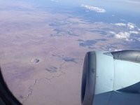
Anyway, regarding the Grand Canyon and my not being remotely American, I had to look up the location of the Meteor crater in Arizona and their proximity to each other.

1024px-Meteor_Crater_Panorama_near_Winslow,_Arizona,_2012_07_11.jpg 220px-The_Meteor_Crater_from_36,000_feet.jpg

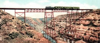
The Grand Canyon is just up the road as the crow flies, but even closer is Canyon Diablo, five miles from the crater.
Mean old town by the sounds. This was a fun read;
CanyonDiabloRailroadBridgeby-DetroitPub1906.jpg
Canyon Diablo​

Part of the Thunderbolts/EU (Electric Universe) guys' studies/experiments illustrate when an electrical bolt hits material mass, and this experiment scales up where we can see a continent or planet with a nice long scar, little pock-mark craters along the sides, as seen on Valles Marineris, Mars, among others.
These same scars are also found (via wiki) on the following bodies, but they are named rift valleys or chasma>> not canyons, but a quick look at any of the highlighted spots here share similar features;


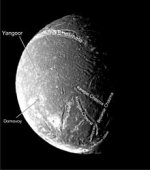
The Uranus system with large 'chasma' believed to be giant rift valley systems, most notably the 1492 km long Messina Chasma on Titania, 622 km Kachina Chasmata on Ariel, Verona Rupes on Miranda, and Mommur Chasma on Oberon.

Some features of Venus, most notably, the 4,000 km Devana Chasma and a part of the western Eistla, and possibly also Alta and Bell Regio have been interpreted by some planetary geologists as rift valleys.
Some natural satellites also have prominent rift valleys.

The 2,000 km long Ithaca Chasma on Tethys in the Saturn system is a prominent example.
Charon's Nostromo Chasma is the first confirmed in the Pluto system, however large chasms up to 950 km wide observed on Charon have also been tentatively interpreted by some as giant rifts, and similar formations have also been noted on Pluto.

A recent study suggests a complex system of ancient lunar rift valleys, including Vallis Rheita and Vallis Alpes.

(From waki; Rift valley)

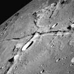
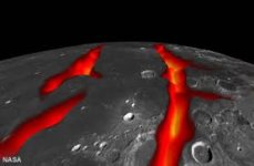
There's a version on the moon too in the Oceanus Percellarum region, and they now say it wasn't an asteroid impact after all, it was rifts formed by lava.
Seems like the same geological feature as the Grand Canyon sans atmosphere to me - but - scientism needs different names and theories for their formation, like 'rifts', valleys caused by erosion, magma rivers, earthquakes, volcanoes and tectonic crust formations splitting apart...

But for the love of God never, ever mention the clearly illustrated electrical phenomena by the Electric Universe/Thunderbolts lab.
Heavens no.

Something interesting was the proximity of Canyon Diablo to the Meteor crater, and also the Grand Canyon as I said. These are both officially canyons, and Canyon Diablo looks as if it *might* have been formed by the mainstream water erosion narrative as this short 1min vid suggests, due to its soft-formed sides;


The Grand Canyon does not follow that same soft rock form. It is jagged in places at it's edges, still 'raw' from the bolt which made it? Was Canyon Diablo scarred from an electrical bolt too, but further back in time- maybe an earlier fly-by, and water over time eroded the sides smoother compared to the GC?
No clue, but here is the vague, non-committal idea from the official geologist paper I got the pictures from;
"Understanding What You Can't Observe Directly

This new idea for the formation of Oceanus Procellarum is a theory based upon remotely collected information.
It might be correct or cast aside as new ideas or new information become available.
Even if a team of humans visited the moon and collected drilling or seismic data across Oceanus Procellarum, their ability to improve on this theory might not be possible.
The answer is difficult to "know" because the available data will always be fragmentary and subject to interpretation."


So they don't know, but be sure that they know more than YA.
Looks to me that places without atmosphere appear as dried up scars.
Moon's version (second image is an artists impression of the "lava" that 'might have' caused the rifts).

Moons scar.jpg Moons rift.jpg

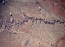
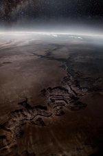
Grand Canyon from space, in our happy little atmospheric bubble;
Grand Canyon from space.jpg Grand Canyon, Space.jpg


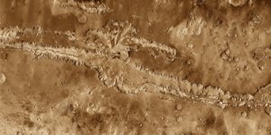
Mars' Valles Marineris

vallesmarineris500.jpg

The Kachina Chasmata are the longest canyon or system of canyons on the surface of the Uranian moon 'Ariel'.

Ariel chasma.jpg
1540: ...the Grand Canyon was seen for the first time
One thing I've noticed time and time again around Italy is the routine paintings of ruins with plants growing out of them dated to the 1600's. I'd say you're right KD, and I'm also convinced this happened more than just the one time.
I'm pretty sure you know my take on all this from the past few years but for those who don't, I love thinking about it and will repeat what I know or intuit from all the evidence and books available whenever the subject arises because I'm always adding to it.

Both paintings below were found in the same palace on one of the islands in Lake Maggiore recently. So one bout of chaos could have happened fairly recently in the scheme of things.

Painting,Maggiore - 1.jpg

Below dates artists life, and says 'View of Roman ruins.'

Painting,Maggiore1 - 1.jpg Painting,Maggiore2 - 1.jpg

Paradigm shift.. waiting very patiently for you.
 
Last edited:
Quivira is a place named by explorer Francisco Coronado in 1541, for the mythical "Seven Cities of Gold" that he never found.
The first thing I think: not again Seven.

- Antwerp, the Giant was beaten by Bravo and the Seven Schaken (* that is best translated as seven chess pawns and they were seven young boys)
- north Amerika was called septentrional (something with Seven) or names like this because they now translate that from Latin as "north" because the big bear/ big dipper in north has seven stars.
- the Seven founding fathers of America
- the Seven ports of Thebes (greece)
- God created the world in Seven days
- Seven wonders of the world (Amsterdam Palace was the eight)
- Seven beauties
- Seven against Thebes do notice the Antigoon in the story.

Wait, what?
Did you ever heard of this Petra (Jordan) like buildings?
I was looking for that perculiarfort where that Indian chief went to near the founding president thing because nobody seems to know where that fort came from.

And in India there is Gandicota the "forgotten" Grand Canyon.
* edit.
The Navajo now use the term in the sense of referring to "ancient people" or "ancient ones
 
Last edited:
I don't really have anything to add other than to simply concur with your take on the veracity of dendro "science". studied this for years along with ice cores and in my seeking, the dating game is alive and well in both (I was looking at climate and weather patterns), a lot of circular reasoning

Add me to this list. Every attempt into dendrochronology I've taken, I've walked away very unimpressed. It's a bit more elaborate than just counting the rings too, which as KD notes, could be problematic if the rate of ring growth not consistent throughout time.

This is a pretty telling summary:

In dendrochronology wood samples are dated according to the tree rings they contain. The dating process consists of comparing the sequence of tree ring widths in the sample to a dated master sequence. Assuming that a tree forms exactly one ring per year a simple sliding algorithm solves this matching task.

But sometimes a tree produces no ring or even two rings in a year. If a sample sequence contains this kind of inconsistencies it cannot be dated correctly by the simple sliding algorithm. We therefore introduce a O(α2mn+α4(m+n)) algorithm for dating such a sample sequence against an error-free master sequence, where n and m are the lengths of the sequences. Our algorithm takes into account that the sample might contain up to α missing or double rings and suggests possible positions for these kind of inconsistencies. This is done by employing an edit distance as the distance measure.

If someone would tell me when experiment got replaced by mathematical algorithms in the scientific method, I'd be interested. Actually, no, I don't care. We've already left the realm of the empirical to the magical land of suppositional correlation, where most of academia now resides.

Continuing, this is where we run into some serious issues:

In dendrochronology a wood sample is characterized by the sequence of its tree ring widths.2 Such a sequence consists of positive real values each describing the width of one tree ring, in the same order as the tree rings occur in the sample. Since trees growing under similar conditions (especially climatic conditions like rainfall) build similar tree rings, it is possible to successfully compare certain tree ring sequences. In fact, the usual way of dating tree ring sequences in dendrochronology is to compare the undated sequence to a dated sequence. This procedure, called crossdating, is a fundamental task in dendrochronology....
In practice, before two tree ring width sequences are compared they have to be filtered. This so-called standardization process cleans the data from individual trends, which usually are long term trends. For instance with growing age the tree rings usually become thinner. Thus after standardization only general trends which occur in several tree ring sequences remain. Typically high-pass filters like the percentage of a five-year running mean or the logarithmic difference are used. In the sequel a tree ring sequence will thus be a standardized sequence of tree ring widths, which is a sequence of real values.

Assuming that the trees being considered have built exactly one ring each year, a crossdating can be performed by sliding the undated sample sequence along the dated master sequence, which is usually quite longer, starting and ending with a certain constant minimum overlap of e.g., 50 rings. At each position the distance (according to a predefined distance measure) between the overlapping parts of the sequences is computed and the position yielding the best distance is proposed as the correct dating position....
...However, the assumption made above that a tree ring sequence contains exactly one value per year is not always true. It happens that due to bad growing conditions a tree does not build a ring around the whole stem or even not at all, which can result in a missing ring in the tree ring sequence. Also mistakes during the measurement of very narrow rings can lead to missing rings. Moreover, climatic variations during a year can cause a tree to build two rings a year, a double ring.

If the sequences to be compared contain missing or double rings most matching algorithms do not produce satisfying results since they do not take into account the transposition in time which is caused by a missing or a double ring. The usual approach to date a sample sequence which may contain inconsistencies against a clean master sequence is to split up the sample into shorter parts and to date each part on its own (either manually or using Cofecha). Finally possible positions for missing or double rings are manually concluded. Cofecha is a quality control tool which checks a set of dated samples for mutual dating consistency by splitting up each sequence into small pieces and comparing these to the other sequences. This leads to a lot of information to be evaluated. The information needed to deduce a possible missing ring (i.e., when the pieces to the right of a missing ring position date all to one year later) is then available, but a missing ring is not explicitly proposed.
Everyone clear on that? Essentially, we apply the results of looking at one tree to other trees in the area, then extrapolate back through time. We then run into the problem with virtually every dating method (dendrochronology helps verify the accuracy of carbon dating methods, for instance) that we need KNOWN DATED SAMPLES to validate our guesses. Now, as usual, maybe I'm just a simpleton, but how do you get a known dated sample for something like this?

An ultra-long tree-ring width chronology (9111 years long, 7109 B.C. to A.D. 2002) has been established based on the analysis and dating of 1432 sub-fossil/dry-dead wood samples and cores from 335 living trees. The material was collected from tree-line or near-tree-line sites (c. 2000 to 2400 m a.s.l.) mainly in the central eastern Alps. This tree-ring chronology is the longest continuous high-mountain chronology in the world.
Anyway, I admit that I may be being a bit dismissive, but I think my skepticism is warranted to balance out the folks that take this sort of thing as gospel. Any study of the past is going to be incredibly difficult without a time machine, so some fundamental presumptions will have to be made. The problem is, I think a lot of what calls itself "science" has forgotten about that part of it and most of the "research" available in many fields is nothing more than a house of cards which can't handle even beginning to contemplate some of the issues that KD brings up on this site. So 16th century maps cannot be accurate, geographic change does not happen rapidly (except when it does).

There is a slight possibility that the events of 1650s, in reality took place in 1750s.

Right, and along those lines then, considering the Columbus 1592 thing, then de Cárdenas could have been exploring in 1640.

I'm really starting to think that all these dates might be next to worthless though. My sense is that the "discovery of North America" (read: rediscovery) all happened post-calamity. I do not discount multiple events, heading into the 19th century, but the ones that seemed to have changed the very layout of North America I think happened prior to the European invasion. The fact that the maps are different in the 16th and 17th centuries could be more attributed to a sort of lag... in other words, they were operating off of "pre-reset" information, so to speak.

So, it's possible that de Cárdenas did in fact see the Grand Canyon AND it was a new development. I'm not sure we can say we any sort of certainty whenever these maps were produced, relative to today, and if we're speculating that a world-changing cataclysm was swept under the rug/forgotten about, we're already so far off the "accepted" chronology that literally anything is possible.
 
If someone would tell me when experiment got replaced by mathematical algorithms in the scientific method, I'd be interested. Actually, no, I don't care.
haha, it might have been about the same time magic got named a national treasure in the united states of alaska ... magic is very real, it is very different from the way it is presented

A bill to recognize magic as a "rare and valuable art form and national treasure" was introduced

House of Representatives Bill Would Recognize Magic as 'National Treasure'
 
Last edited:
Add me to this list. Every attempt into dendrochronology I've taken, I've walked away very unimpressed. It's a bit more elaborate than just counting the rings too, which as KD notes, could be problematic if the rate of ring growth not consistent throughout time.

This is a pretty telling summary:


If someone would tell me when experiment got replaced by mathematical algorithms in the scientific method, I'd be interested. Actually, no, I don't care. We've already left the realm of the empirical to the magical land of suppositional correlation, where most of academia now resides.

Continuing, this is where we run into some serious issues:


Everyone clear on that? Essentially, we apply the results of looking at one tree to other trees in the area, then extrapolate back through time. We then run into the problem with virtually every dating method (dendrochronology helps verify the accuracy of carbon dating methods, for instance) that we need KNOWN DATED SAMPLES to validate our guesses. Now, as usual, maybe I'm just a simpleton, but how do you get a known dated sample for something like this?


Anyway, I admit that I may be being a bit dismissive, but I think my skepticism is warranted to balance out the folks that take this sort of thing as gospel. Any study of the past is going to be incredibly difficult without a time machine, so some fundamental presumptions will have to be made. The problem is, I think a lot of what calls itself "science" has forgotten about that part of it and most of the "research" available in many fields is nothing more than a house of cards which can't handle even beginning to contemplate some of the issues that KD brings up on this site. So 16th century maps cannot be accurate, geographic change does not happen rapidly (except when it does).


Right, and along those lines then, considering the Columbus 1592 thing, then de Cárdenas could have been exploring in 1640.

I'm really starting to think that all these dates might be next to worthless though. My sense is that the "discovery of North America" (read: rediscovery) all happened post-calamity. I do not discount multiple events, heading into the 19th century, but the ones that seemed to have changed the very layout of North America I think happened prior to the European invasion. The fact that the maps are different in the 16th and 17th centuries could be more attributed to a sort of lag... in other words, they were operating off of "pre-reset" information, so to speak.

So, it's possible that de Cárdenas did in fact see the Grand Canyon AND it was a new development. I'm not sure we can say we any sort of certainty whenever these maps were produced, relative to today, and if we're speculating that a world-changing cataclysm was swept under the rug/forgotten about, we're already so far off the "accepted" chronology that literally anything is possible.
I agree with you, fantastic comment!! It comes about my way of thinking about said maps and their PTB dates. I kinda believe that the most advanced maps are actually much more recent than their dates, and that woudn't fit the narrative of linear progression of bull*
Came across an article today about "aztec axe coins" from the mid 1500's and how there's a single piece of paper from the period (sounds legit right??) That confirms the whole axe coin stuff. You can't make this crap up OMG
 
The Grand Canyon is a site of Ruins.
This demolition occurred perhaps during the late 1700's according to the linear expression of time matrix programs.
What Remains Of The Grand Canyon is another Crime-Scene Cover-Up.

Another embarrassing example of mind control programming by brainwashing people to appreciate and adore Ruins posing as Mother Natures Epic Majestic Mountain Ranges
 
Not quite sure where this info. belongs, only that it's interesting in relation to the Americas.
I follow a few thinkers on faceberg, and this just came in below.
It was amazing to find these men bandied this sort of info. about so casually over 50years ago, referencing books that went back to the 700's.
Also, that the primary driver of the PAGE has mentioned it all, too. It seems to be slowly seeping in to the consciousness of everyone online.

This is from a FB page on Rene Guenon. Italics by the moderator and also the commentator who followed.
Guenon in bold;

-"In Crisis of the Modern World, Guenon leaves this cryptic footnote as an example of something that had been known in the Middle Ages, but subsequently forgotten:
  • “the 'official' discovery of America, with which continent far more extensive relations than is supposed had existed throughout the Middle Ages”
This came to my attention a few days ago when a fellow asked for my opinion on the matter. The temptation is to look for “evidence” in the modern sense, but that is just a dog chasing its tail. Rather, the claim can only make sense as a spiritual, rather than material, history. I recommended the book “The Battle for Amerindia” by Solange Hertz, who agrees with Guenon. She lists more than a dozen medieval writers who knew of a “world beyond the oceans”. Columbus himself believed that the Garden of Eden was in the Americas."

The only comment so far continues the theme;

-There's more from Guénon about this :
  • "Sir, Here is the information I have just received concerning what you asked me about pre-Columbian relations with America: the Celtic monks of Ireland would have gone to evangelize the North-West of Canada, and from there they would have descended -being as far as Peru, where we find traces of a white evangelizer whom we have identified wrongly with the apostle St. Thomas. As for the Templars, it is in Mexico that they would have had possessions. All of this can be found in the works of Eugène Beauvois, whose separate prints are in the National Library where they can be easily consulted.
  • On the other hand, I saw that it recently appeared a book entitled “Vers les Terres fortunées [Towards the Fortunate Lands], 780-1490” by Mornand (Éditions de la Nouvelle France, 1946) which, according to the account which was given, also relates to the history of Irish monks in America; the date of 780 would be, if I understood correctly, that of the foundation of their first establishments which would thus be prior to the Norman expeditions."
- To Théodore Monod, 24 Aug 1947
 
Back
Top