A few days ago I was looking at some older (17th-18th century) maps when two words attracted my attention. Those words were "Tahuglauk" and "Mozeemlek". Googling the words revealed that Google knows what Wikipedia does not. Surprisingly there was very little contemporary information pertaining to the topic. At the same time I found several 19th century books in Google Books. Started reading and found the information rather interesting, though there was not much of it. Tahugluak and Mozeemlek were two, apparently white, nations/tribes of Native American people.
Here is a couple of instances I found intriguing, "Tahuglauk wear their beards two fingers' breadth long; that their garments reach down to their knees; that they cover their heads with a sharp-pointed cap; that they always wear a long stick or cane in their hands, which is tipped, not unlike what we use in Europe; that they wear a sort of boot upon their legs which reach up to their knee; that their women never show themselves, which perhaps proceeds from the same principle that prevails in Italy and Spain;"
The other one was, "the lower part of that river is adorned with six noble cities, surrounded with stone cemented with fat earth; that the houses of these cities have no roofs, but are open above, like a platform, as you see them drawn in the map; that besides the above-mentioned cities, there are above an hundred towns".

I thought about sharing the info I came upon, but felt that a certain prerequisite was missing, so I put this little article together: Bizarre transformation of the North American Continent: 16th through 19th centuries. Please go over it first before continuing. I think it might contribute to those few possible reasons why the people of Tahugluak and Mozeemlek were never found.
Below you will find the entire chunk of original information pertaining to the people of Tahugluak and Mozeemlek published in 1852. Allegedly this account took place in 1698. The person, responsible for documenting it was Baron la Houtan, "Lord Lieutenant of the French Colony at Placentia in Newfoundland".

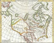
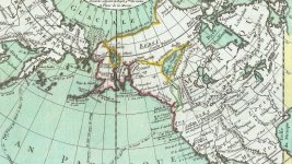
1772 Vaugondy - Diderot Map
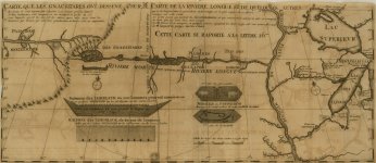
"It was at this place that the baron received his information respecting the lake of salt water. He says, "Two days after, the cacick" (of the Gnacsitares)" came to see me, and brought with him four hundred of his own subjects and four Mozeemlek savages, whom I took for Spaniards. My mistake was occasioned by the great difference between these two American nations; for the Mozeemlek savages were clothed, they had a thick bushy beard, and their hair hung down under their ears; their complexion was swarthy, their address was civil and submissive, their mien grave, and their carriage engaging. Upon these considerations I could not imagine that they were savages, though, after all, I found myself mistaken. These four slaves gave me a description of their country, which the Gnacsitares represented by way of a map upon a deer's skin, as you see it drawn in this map. Their villages stand upon a river that springs out of a ridge of mountains, from which the Long River likewise derives its source, there being a great many brooks there, which, by a joint confluence, form the river."
* The boats, with a drawing, are thus described in the map: " The vessels used by the Tahuglauk, in which two hundred men may row. provided they are such forms as the Mozeemlek people drew me on the bark of trees. According to my computation, such a vessel must be one hundred and thirty feet long from the prow to the stern."
* On that part of the map which is confessedly derived from Indian authority is the following note: "A map drawn upon stag-skins by Gnacsitares, who gave me to know latitudes of all places marked in it, by pointing to the respective places of heavens that one or t'other corresponded to; for by this means I could adjust the latitude to half a degree or little more; having first received from them a computation of distances in fazons, each of which I compute to be three long French leagues."
"The Mozeemlek nation is numerous and puissant. The four slaves of that country informed me that at the distance of one hundred and fifty leagues from the place I then was, their principal river empties itself into a salt lake of three hundred leagues in circumference, the mouth of which is two leagues broad; that the lower part of that river is adorned with six noble cities, surrounded with stone cemented with fat earth; that the houses of these cities have no roofs, but are open above, like a platform, as you see them drawn in the map; that besides the above-mentioned cities, there are above an hundred towns, great and small, round that sort of sea, upon which they navigate with such boats as you see drawn in the map; that the people of that country made stuffs, copper axes, and several other manufactures, which the Outagamis and my other interpreters could not give me to understand, as being altogether unacquainted with such things; that their government was despotic, and lodged in the hands of one great head, to whom the rest paid a trembling submission; that the people upon that lake are called Tahuglauk, and are as numerous as the leaves of trees, (such is the expression that the savages use for an hyperbole) that the Mozeemlek people supply the cities or towns of the Tahuglauk with great numbers of little calves, which they take in the above-mentioned mountain; and that the Tahuglauk make use of these calves for several ends; for they not only eat their flesh, but bring 'em up to labour, and make clothes, boots, &c. of their skins. They added, that it was their misfortune to be took prisoners by the Gnacsitares with war, which had lasted for eighteen years; but that they hoped a peace would be speedily concluded, upon which the prisoners would be exchanged, pursuant to the usual custom. I could pump nothing further out of 'em, with relation to the country, commerce, and customs of that remote nation: all they could say was that the great river of that nation runs along westward, and that the salt lake into which it falls is three hundred leagues in circumference and thirty in breadth, its mouth stretching a great way to the southward." "I would have fain satisfied my curiosity, in being an eyewitness of the manners and customs of the Tahuglauk, but that being impracticable, I was forced to be instructed at secondhand by these Mozeemlek slaves; who assured me upon the faith of a savage that the Tahuglauk wear their beards two fingers' breadth long; that their garments reach down to their knees; that they cover their heads with a sharp-pointed cap; that they always wear a long stick or cane in their hands, which is tipped, not unlike what we use in Europe; that they wear a sort of boot upon their legs which reach up to their knee; that their women never show themselves, which perhaps proceeds from the same principle that prevails in Italy and Spain; and in fine, that this people are always at war with the puissant nations that are seated in the neighborhood of the lake, but withal that they never disquiet the strolling nations that fall in their way by reason of their weakness - an admirable lesson for some princes in the world, who are so much intent upon the making use of the strongest hand. This was all I could gather upon that subject. My curiosity prompted me to desire a more particular account; but unluckily I wanted a good interpreter: and having to do with several persons that did not well understand themselves, I could make nothing of their incoherent fustian."
A detailed map accompanies this imaginative voyage up this most imaginary river. It is represented as flowing due east through 25 degrees of longitude, numerous streams putting into it on either side, with mountains, islands, villages, and domains of Indian tribes, whose very names have at this day sunk into oblivion. The map was afterward published, in 1710, by John Senex, F. R. S., as a part of "North America, corrected from the observations communicated to the Royal Society at London and the Royal Academy at Paris," and I have annexed it as a specimen of the geographical knowledge of America enjoyed at that period.'".
KorbenDallas note: Mind that the excerpt is from a book published in 1852, which is 154 years after the original account. Hence the last paragraph above.
Just like I said above, from what we know, neither Tahuglauk nor Mozeemlek were ever found. Of course, the Lord Lieutenant of the French Colony at Placentia in Newfoundland, was later accused of recording made up stories: Fictitious Discoveries in America. Somewhat similar to the other cases: Tartary, Africa, North America, etc.
As usually, I prefer to consider the original sources, before I do our contemporary ones. Somehow, I have very little trust in the dogmatic teachings of today.
There are a few examples of Native Americans looking somewhat different from what we are used to. At least on some of the images. One of them is Chief Tecumseh.

A myth, or a rumor, or a legend (or whatever you wanna call it) covering the topic of the white Native Americans (both Americas) has been around for a while. I don't think it was ever officially confirmed. But if we imagine for a split second that there was any truth to it, we will probably come up with a reasonable question: where are they? Well... I don't know. Could they be here?


A while ago I saved the below image representing the advancement of the North American newcomers to the west. Might as well use it now.

Columbus set foot on Hispaniola in 1492. Cortez overthrew the entire Aztec Empire by 1521. Pizarro conquered Peru and defeated Incas by 1535. Yet the North American settlers barely made it to the Mississippi river by 1820. 300 year difference is bizarre. Did North American natives have better defensive equipment? Well, may be they did. May be they had an army to defend themselves. The one we will never be told about. (fyi - I know the official version. I just find it hard to believe.)
Here is a couple of instances I found intriguing, "Tahuglauk wear their beards two fingers' breadth long; that their garments reach down to their knees; that they cover their heads with a sharp-pointed cap; that they always wear a long stick or cane in their hands, which is tipped, not unlike what we use in Europe; that they wear a sort of boot upon their legs which reach up to their knee; that their women never show themselves, which perhaps proceeds from the same principle that prevails in Italy and Spain;"
The other one was, "the lower part of that river is adorned with six noble cities, surrounded with stone cemented with fat earth; that the houses of these cities have no roofs, but are open above, like a platform, as you see them drawn in the map; that besides the above-mentioned cities, there are above an hundred towns".
I thought about sharing the info I came upon, but felt that a certain prerequisite was missing, so I put this little article together: Bizarre transformation of the North American Continent: 16th through 19th centuries. Please go over it first before continuing. I think it might contribute to those few possible reasons why the people of Tahugluak and Mozeemlek were never found.
Below you will find the entire chunk of original information pertaining to the people of Tahugluak and Mozeemlek published in 1852. Allegedly this account took place in 1698. The person, responsible for documenting it was Baron la Houtan, "Lord Lieutenant of the French Colony at Placentia in Newfoundland".
1772 Vaugondy - Diderot Map
Exploration and survey of the Valley of the Great Salt Lake of Utah:
including a reconnoissance of a new route through the Rocky Mountains - excerpt
- archive link -
including a reconnoissance of a new route through the Rocky Mountains - excerpt
- archive link -
"It was at this place that the baron received his information respecting the lake of salt water. He says, "Two days after, the cacick" (of the Gnacsitares)" came to see me, and brought with him four hundred of his own subjects and four Mozeemlek savages, whom I took for Spaniards. My mistake was occasioned by the great difference between these two American nations; for the Mozeemlek savages were clothed, they had a thick bushy beard, and their hair hung down under their ears; their complexion was swarthy, their address was civil and submissive, their mien grave, and their carriage engaging. Upon these considerations I could not imagine that they were savages, though, after all, I found myself mistaken. These four slaves gave me a description of their country, which the Gnacsitares represented by way of a map upon a deer's skin, as you see it drawn in this map. Their villages stand upon a river that springs out of a ridge of mountains, from which the Long River likewise derives its source, there being a great many brooks there, which, by a joint confluence, form the river."
* The boats, with a drawing, are thus described in the map: " The vessels used by the Tahuglauk, in which two hundred men may row. provided they are such forms as the Mozeemlek people drew me on the bark of trees. According to my computation, such a vessel must be one hundred and thirty feet long from the prow to the stern."
* On that part of the map which is confessedly derived from Indian authority is the following note: "A map drawn upon stag-skins by Gnacsitares, who gave me to know latitudes of all places marked in it, by pointing to the respective places of heavens that one or t'other corresponded to; for by this means I could adjust the latitude to half a degree or little more; having first received from them a computation of distances in fazons, each of which I compute to be three long French leagues."
"The Mozeemlek nation is numerous and puissant. The four slaves of that country informed me that at the distance of one hundred and fifty leagues from the place I then was, their principal river empties itself into a salt lake of three hundred leagues in circumference, the mouth of which is two leagues broad; that the lower part of that river is adorned with six noble cities, surrounded with stone cemented with fat earth; that the houses of these cities have no roofs, but are open above, like a platform, as you see them drawn in the map; that besides the above-mentioned cities, there are above an hundred towns, great and small, round that sort of sea, upon which they navigate with such boats as you see drawn in the map; that the people of that country made stuffs, copper axes, and several other manufactures, which the Outagamis and my other interpreters could not give me to understand, as being altogether unacquainted with such things; that their government was despotic, and lodged in the hands of one great head, to whom the rest paid a trembling submission; that the people upon that lake are called Tahuglauk, and are as numerous as the leaves of trees, (such is the expression that the savages use for an hyperbole) that the Mozeemlek people supply the cities or towns of the Tahuglauk with great numbers of little calves, which they take in the above-mentioned mountain; and that the Tahuglauk make use of these calves for several ends; for they not only eat their flesh, but bring 'em up to labour, and make clothes, boots, &c. of their skins. They added, that it was their misfortune to be took prisoners by the Gnacsitares with war, which had lasted for eighteen years; but that they hoped a peace would be speedily concluded, upon which the prisoners would be exchanged, pursuant to the usual custom. I could pump nothing further out of 'em, with relation to the country, commerce, and customs of that remote nation: all they could say was that the great river of that nation runs along westward, and that the salt lake into which it falls is three hundred leagues in circumference and thirty in breadth, its mouth stretching a great way to the southward." "I would have fain satisfied my curiosity, in being an eyewitness of the manners and customs of the Tahuglauk, but that being impracticable, I was forced to be instructed at secondhand by these Mozeemlek slaves; who assured me upon the faith of a savage that the Tahuglauk wear their beards two fingers' breadth long; that their garments reach down to their knees; that they cover their heads with a sharp-pointed cap; that they always wear a long stick or cane in their hands, which is tipped, not unlike what we use in Europe; that they wear a sort of boot upon their legs which reach up to their knee; that their women never show themselves, which perhaps proceeds from the same principle that prevails in Italy and Spain; and in fine, that this people are always at war with the puissant nations that are seated in the neighborhood of the lake, but withal that they never disquiet the strolling nations that fall in their way by reason of their weakness - an admirable lesson for some princes in the world, who are so much intent upon the making use of the strongest hand. This was all I could gather upon that subject. My curiosity prompted me to desire a more particular account; but unluckily I wanted a good interpreter: and having to do with several persons that did not well understand themselves, I could make nothing of their incoherent fustian."
A detailed map accompanies this imaginative voyage up this most imaginary river. It is represented as flowing due east through 25 degrees of longitude, numerous streams putting into it on either side, with mountains, islands, villages, and domains of Indian tribes, whose very names have at this day sunk into oblivion. The map was afterward published, in 1710, by John Senex, F. R. S., as a part of "North America, corrected from the observations communicated to the Royal Society at London and the Royal Academy at Paris," and I have annexed it as a specimen of the geographical knowledge of America enjoyed at that period.'".
KorbenDallas note: Mind that the excerpt is from a book published in 1852, which is 154 years after the original account. Hence the last paragraph above.
Just like I said above, from what we know, neither Tahuglauk nor Mozeemlek were ever found. Of course, the Lord Lieutenant of the French Colony at Placentia in Newfoundland, was later accused of recording made up stories: Fictitious Discoveries in America. Somewhat similar to the other cases: Tartary, Africa, North America, etc.
As usually, I prefer to consider the original sources, before I do our contemporary ones. Somehow, I have very little trust in the dogmatic teachings of today.
There are a few examples of Native Americans looking somewhat different from what we are used to. At least on some of the images. One of them is Chief Tecumseh.
A myth, or a rumor, or a legend (or whatever you wanna call it) covering the topic of the white Native Americans (both Americas) has been around for a while. I don't think it was ever officially confirmed. But if we imagine for a split second that there was any truth to it, we will probably come up with a reasonable question: where are they? Well... I don't know. Could they be here?
- why would new "colonists" want the world to know that there was a whole bunch of white people killed in the process of advancing (conquering) to the West? We know that "settlers" fought against Native Americans in the process of moving West, we have drawings, sketches, engravings, documents, books, memoirs as proof. Clint Eastwood-like movies ingrained an image of an average Native American for generations to come. But what if this land was already inhabited by a multi-racial local civilization?... or not so local?
- why did we have Russian (or may be Tartarian) Fort Elizabeth in Hawaii? And why does it have distinctive traces of the star shaped design?
A while ago I saved the below image representing the advancement of the North American newcomers to the west. Might as well use it now.
Columbus set foot on Hispaniola in 1492. Cortez overthrew the entire Aztec Empire by 1521. Pizarro conquered Peru and defeated Incas by 1535. Yet the North American settlers barely made it to the Mississippi river by 1820. 300 year difference is bizarre. Did North American natives have better defensive equipment? Well, may be they did. May be they had an army to defend themselves. The one we will never be told about. (fyi - I know the official version. I just find it hard to believe.)
- is there any official historian out there taking into consideration the possible transformation of the continents? Of course not, because there is no such official theory. We are used to thinking that ancient cartographers were fantasy artists of their time. After all, why would they care about an accurate representation of this planet on their maps? Yet if there was such a thing as global cataclysm of this magnitude, the re-balancing of the world powers would be inevitable.
- Various dates: Google Search Link
- 1806 - Philadelphia Medical and Physical Journal, Volume 2
- 1812 - A General Collection of the Best and Most Interesting Voyages, Volume 13
- 1851 - The Senate of the United States - Special Session - Volume 2
- 1852 - Exploration and Survey of the Valley of the Great Salt Lake of Utah
- 1873 - The Canadian Journal of Science, Literature and History, Volume 13
- Contemporary research: The Mysterious 1688 Journey of M. Lahontan
- Contemporary bashing: Fictitious Discoveries in America
- Other used names: Tahuglauk = Tahugluck, Mozeemlek = Moozemleck = Moosemlek.


